2014 looks like it’s going to be a great year, we’re already hard at work preparing tDAR for new software features, and working with clients to upload documents, data sets and images into tDAR. tDAR grew quite a bit in 2013, we had two major software updates (in situ, and jar) including: a new face for tDAR, we added the ability to upload geospatial data into tDAR, and added new features such as enhancing the creator pages in tDAR to include related keywords and collaborators among many others.
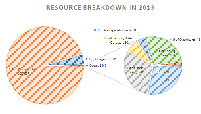
Almost 10,000 new items were added to tDAR in 2013 including GIS data from Tikal, a large collection of images of Mimbres Ceramics, and reports from the Permian Basin, the Anasazi Origins Project, Colonial Mobile, Dyess Air Force Base, and CRM Reports from Brockington & Associates, Hartgen Archaeological Associates, and PaleoResearch Institute.
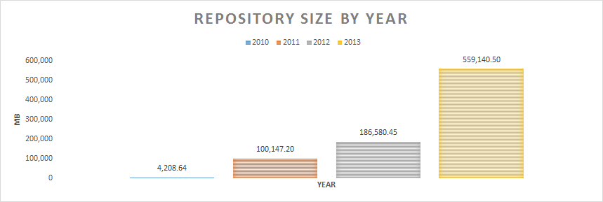
The repository now archives almost 600 GB of content, nearly triple the size of the archive in 2012.
Usage Statistics
While we do not maintain detailed statistics on users or use to protect user and contributor privacy, we can share some interesting aggregate data. Below are the most frequently viewed and downloaded resources.
Most Viewed
- Tikal Report 11: Map of the Ruins of Tikal, El Petén, Guatemala and Georeferenced Versions of the Maps Therein
- Style III (Bowl)
- Utility (vessel)
- “Style II, Style III” (Bowl)
- Style III (Bowl)
- Style III (Bowl)
- Style III (Bowl)
- Vanoli Project
- Beyond the North Gate: Archeology on the Outskirts of Colonial Albany. Archeological Data Retrieval, Quackenbush Square Parking Facility, Broadway, Albany, New York
- Tikal Report 11: Map of the Ruins of Tikal, El Petén, Guatemala
Most Downloaded
- Archaeological Data Recovery at Riverfront Village (38AK933): A Mississippian/Contact Period Occupation
- Style III (Bowl)
- Ethics and Permission to Access MimPIDD
- The CityScape Project: Archaeological Investigations of Pueblo Patricio and Block 22 in the Original Phoenix Townsite Phoenix, Maricopa County, Arizona
- Tikal Report 11: Georeferenced Map- “Ruins of Tikal” (with border)
- Archaeological Data Recovery at Colleton River Plantation (38BU647) Beaufort County, South Carolina: A Study of an Early Nineteenth Century Slave Settlement
- Formative Settlements on the Pinaleno Mountains Bajada: Results of Phased Archaeological Treatment of Sites AZ CC:6:40 and AZ CC:6:43 (ASM) within the U.S. Highway 191 Right-of-Way between Mileposts 110.40 and 117.60 south of Safford, Graham County, Arizona
- Relocation of a Portion of Hampstead Cemetery, 46 Reid Street, Charleston, South Carolina
- Tikal Report 11: Georeferenced Map- “Ruins of Tikal” (without border)
- Style III (Bowl)
Site Type Keywords (Most Used)
Site Name Keywords (Most Used)
Culture Keywords (Most Used)
Material Keywords (Most Used)
Geographic Keywords (Most Used)
Other Keywords (Most Used)
People (Most Used)
Institutions (Most Used)
- Maryland Archaeological Conservation Lab
- South Carolina Institute of Archaeology and Anthropology, University of South Carolina
- Hartgen Archeological Associates, Inc.
- Internet Archaeology
- Brown University
- USDI Bureau of Reclamation, Phoenix Area Office
- University of South Alabama Center for Archaeological Studies
- Brockington and Associates, Inc.
- Shaw Air Force Base, South Carolina
- Brockington and Associates, Inc.

